Planetary boundary-layer height retrievals from micropulse lidar at multiple ARM sites worldwide
Submitter
Li, Zhanqing — University of Maryland
Roldan-Henao, Natalia — University of Maryland
Area of research
Atmospheric Thermodynamics and Vertical Structures
Journal Reference
Science
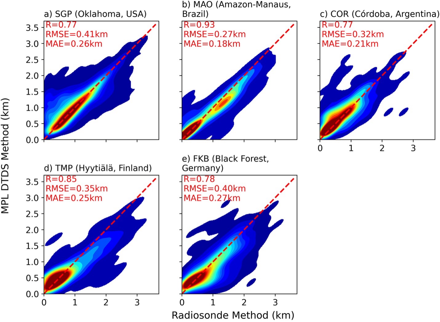
The planetary boundary-layer height (PBLH) is a crucial parameter for various atmospheric applications, and lidar measurements are frequently used to track its diurnal evolution. However, lidar-based PBLH retrievals have large uncertainties depending on the algorithm used, especially in stable conditions or when there are multiple aerosol layers. To address this problem, this study evaluates the PBLH products at five U.S. Department of Energy Atmospheric Radiation Measurement (ARM) user facility sites using the Different Thermo-Dynamic Stabilities (DTDS) algorithm based on micropulse lidar (MPL) measurements. While the DTDS method was originally developed at ARM's Southern Great Plains observatory (SGP), it is valid at other sites with distinct conditions. The products can account for the diurnal variations of PBL under all-sky conditions.
Impact
This study provides a new comprehensive lidar-based PBLH data set at five ARM facilities, including the SGP, the Green Ocean Amazon—GoAmazon (MAO); the Cloud, Aerosol, and Complex Terrain Interactions—CACTI (COR); the Convective and Orographically Induced Precipitation Study (FKB), and the Biogenic Aerosols—Effects on Clouds and Climate—BAECC (TMP). The results attest to the robustness of the DTDS-derived PBLH, with correlations against radiosonde-derived PBLH ranging between 0.77 at COR and 0.93 at MAO and the root-mean-square error ranging from 0.27 km at MAO to 0.41 km at SGP. In addition, the causes of their discrepancies are explored, including mismatches between the MPL and radiosonde techniques.
Summary
This study assesses the performance of the Different Thermo-Dynamics Stabilities (DTDS) algorithm in estimating the PBLH (Planetary Boundary-Layer Height) in various environmental and geographical locations. The study uses micropulse lidar data at five ARM sites across the Americas and Europe to calculate the PBLH using DTDS. The results indicate that DTDS estimations exhibit high correlations and small errors when compared to radiosonde-based PBLH estimations. This lays the groundwork for future research and applications related to boundary-layer studies. Lastly, the study addresses the limitations and potential errors in the DTDS algorithm stemming from lidar measurements, uncertainties in radiosonde-based PBLH estimates, and the complexities of atmospheric conditions. These findings underscore the necessity for ongoing improvements and a comprehensive understanding of these factors.


